Elevations in Latrobe Survey
Building images and street elevation changes
 Source: Delaware Public Archives.
As Lucille Toro described in her 1971 thesis "The Latrobe Survey of New Castle 1804-1805", the newly self-governing town commissioned surveys in 1797 (the "Blaney survey") to determine the city's layout, and one in 1804-5 to record the topography for planning grading changes to improve drainage and plan for future growth. This survey contains not only the plan (map) of the Town of New Castle but eleven pages of street "sections." These contain accurate measurements of elevation above the river waterline. For Front Street (The Strand) they also offer wondeful images of all the houses on the northwest side of the street. For other streets, only a few buildings are shown. The Market street view shows Immanuel Church before the 1820 expansion, the Courthouse with adjacent jail yard, workhouse and jail, and, in silhouette, the Presbyterian Church with its door facing towards The Strand. Delaware street shows the Academy, Courthouse, the town's open market shed before the building of the Town Hall and Cloud's row.

Immanuel Church |  Courthouse, jail yard, jail, Presbyterian Church |

Academy, Courthouse (3 sections), market shed, Clouds Row | |

Vine (4th Street) at South: Tan House |

4th & Delaware: Van Dyke office, Tatlow (Amstel) House |

Pearl (W 3rd Street): Judge Booth House (David Finney Inn) from side |

 Orange (E 3rd Street) Kensey Johns House, Archibald Alexander House
|
The drawings show the height above sea level, and proposed regrading. As described in chapter six of the Toro thesis, these changes were implemented gradually. They can be seen today at the Courthouse and Gunning Bedford house which are raised above street level, or the "Old Dutch House", which sits below street level.
Streets Running North East and South West
Images courtesy Delaware Public Archives
| The Strand (Front Street) | Second (Market Street) | W. Third (Pearl Street) | E. Third (Orange Street) | Fourth (Vine Street) | Fifth (Union Street) |
|---|---|---|---|---|---|
 Higher-resolution |  Higher-resolution
|  Higher-resolution
|  Higher-resolution
|  Higher-resolution
|  Higher-resolution
|
Streets Running North West and South East
| South | Delaware | Harmony | Chesnut | (North) |
|---|---|---|---|---|
 Higher-resolution
|  Higher resolution
|  Higher-resolution
|  Higher-resolution
|  Higher-resolution
|
Latrobe's sections have 4 lines (here shown for Market/2nd from Chesnut towards the Town Ditch

- a thin red-shaded line representing the ground level at that time
- a darker, thicker line for the proposed regraded level, including gutters and curbs of cross streets. (See the one for Chesnut street near the left edge of the image).
- a thin horizontal line for the the high water level
- another horizontal line at the bottom that I speculate is just a separator. The distances and directions from it are from the high water line to the proposed ground level, current ground level or middle of the street ("mdl st") or to the level of the adjacent buildings in units of feet, inches and tenths of an inch and the direction. For example, on Front Street at 228 feet from Harmony Street, the Read House (current 42 The Strand) is 5.9.5 W= 5 + (9.5)/12 = 5.79' above high water, and (N)W of the surveyor's locations.
Until 1954, a ferry ran from Chesnut street to Pennsville. To prepare for it, there was considerable regrading of the roads and filling in of the waterfront during the 1930's-1940's in the area between Chesnut and the Narrow Dyke on 2nd/Market (now known as Bull Hill).
Fort Casimir was located somewhere in this area on high ground. Where was it? What was the topography like before the regrading of the streets after 1805?
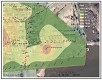 Hypothetical contour maps of the area suggest that the area at Bull Hll and at the end of Chesnut was scraped and the surrounding low areas including 2nd street were filled in.
James L. Meek '12
NC-CHAP
NC-CHAP