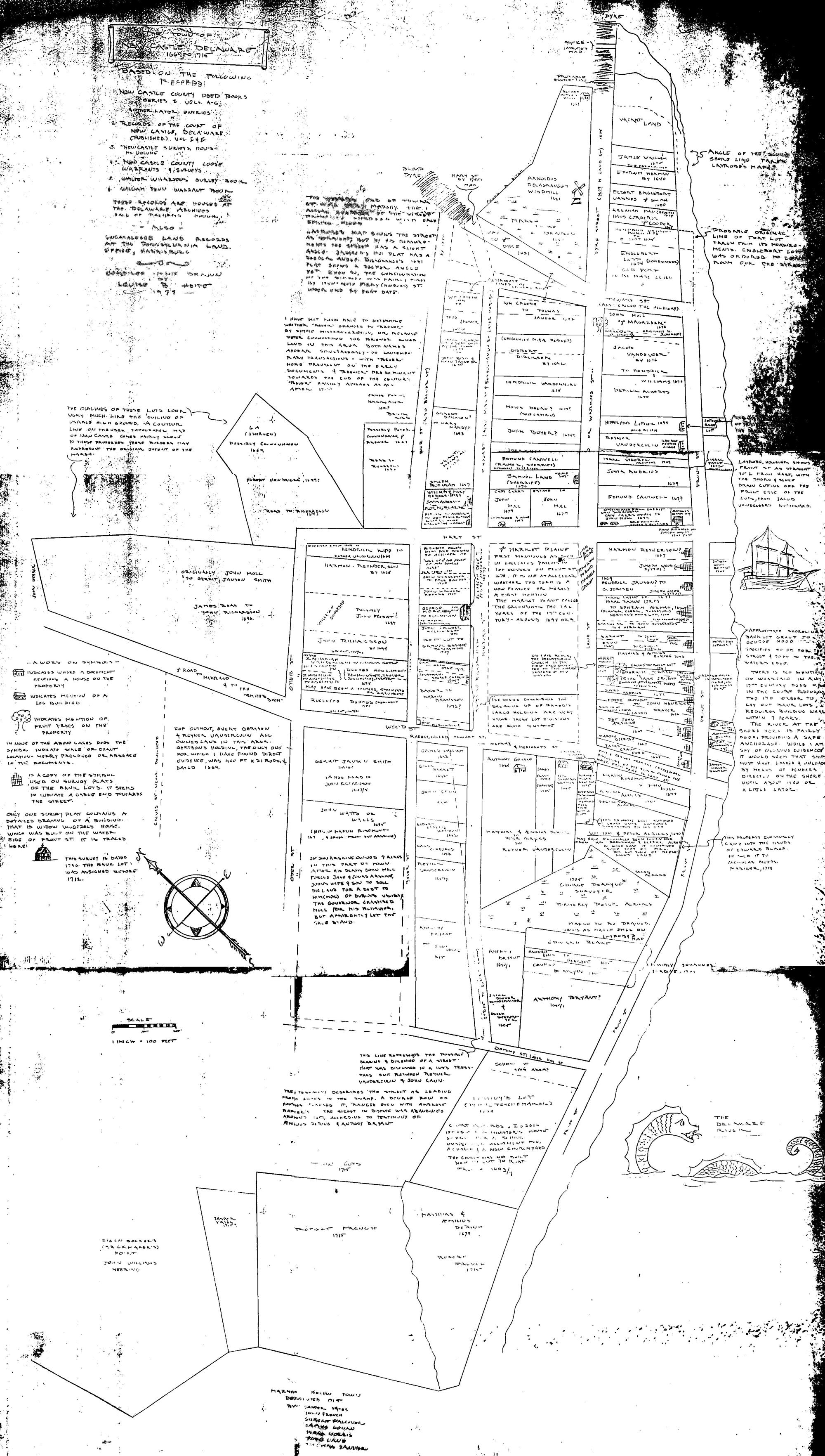
THE NEW CASTLE RIVER FRONT

Jeanette Eckman typed notes, 1947

Character of the Shore - Early Wharves and Piers, Ferries

Contemporary descriptions and records pertaining to the New Castle waterfront in
the Dutch and early English periods, confirm the tradition of a point of land
jutting out into the river at the end of present Chestnut Street. The point
stood high above a sandy beach, and the water line sweeping round it curved
sharply inland north and south. To the north the curve was toward the mouth of a
stream entering the river through a marsh where the canal is and where yachts
and other small boats had safe harbor. To the south the beach curved in a
crescent, coming closest to the Strand at the site of the Read houses, where in
storms at high tide the water is said to have washed up over the bank that rose
above the beach, dashing its spray over the street. A number of early accounts
and records mention the "high bank" along the river. In 1708, a visitor (John
Oldmixon In "The British Expire in America') wrote of New Castle, "it stands
high" and is "finely seated upon the Delaware River." Deep water came close to
the sandy beach, so that landing was said to be easier here than elsewhere on
the west shore of the Delaware.

Upon the ramp or wharf extending from Fort Casimir across the sand to the water,
as shown by the drawing of the Swedish engineer Lindestrom (1654), people,
goods, heavy supplies, and livestock were disembarked directly from the
ocean-going ships. How long this wharf was in use from the time it was built by
Peter Stuyvesant when he erected Fort Casimir In the summer of l65l, is not
clear. From time to time it was damaged by storms and in l662 under the
administration of the last Dutch director, Alexander D'Hinojossa, the wharf was
apparently out of use, for William Beekman, the customs officer for the river,
reported to Stuyvesant: "nor is it possible now to bring goods to the storehouse
on account of the highbank. Mr. D'Hinojossa has therefore to carry the city's
property a long distance with a cart and oxen. When no cartman can be obtained,
the sailors must work it all up on the Strand from the boats."

A few years later when the English under the Duke of York had control of New
Castle, the increased river traffic and shipping must have required the building
of a satisfactory wharf. The site and time of erection has not been established
in this search. However, when the old fort was abandoned in the 1670's for the
new blockhouse on the green, Harmony Street would have been the most direct haul
from the river to the new fort. That "the free wharf" appears In indentures of
1701, and that Harmony Street is called in these indentures "the street to the
free wharf" may indicate that a town wharf at this site replaced the landing
wharf at the old fort, soon after the building of the block house on the Green.

But it is quite possible that the first wharf of the English period was at the
and of Chestnut Streat, using the pilings of the old one, and this may have been
the reason that Englebert Lott was required to level the walls and build on the
foundations of the old fort, when its site was granted to him in l677.

That some of the merchants and other residents along the west side of the Strand
between Delaware and Harmony Streets had their own wharves and landing places in
front of their houses before the arrival of William Penn is indicated in
contemporary items concerning the occupations and activities of these men.

Moses DeGonne, who lived In his small house on the Tile house site before Jan
Boyer bought it in 1678, was a boatman, who carried goods and presumably
passengers in the river trade between the Delaware end the Chesapeake. [The
larger vessels in the seaboard and West Indies trade rounded the soiuth cape of
the peninsula for trade between the Delaware and the Chesapeake; the owners of
small craft did a good business, and often evaded duties by using short overland
hauls of cargo between private wharves at head waters of creeks like the St.
Georges, Drawyers end Appoquinimink flowing Into the Delaware end Back Creek,
Bohemia River, end other tributaries of the Chesapeake.] Whether Jan Boyer
bought the boat with the house is not told in the records but the next year
Boyer is in the carrying business. He refused to take two pasengers up the river
because he was afraid of the smallpox there which he had never had.

The passengers who tried without success to persuade Boyer and then some Swedes
from Christina to take them up the river at a reasonable price, were Jasper
Danckaerts and Peter Sluyter, visiting Dutch labadists, staying at the house of
Eprhaim Herman ao the site of the Reed garden in 1679. They were standing on the
street with the unwilling Boyer and the high-charging Swedes when a boat came
down the river on which the visitors recognized Robert Wade and his wife,
Quakers from Upland   Wade readily agreed to take the visitors up the river with
him on his way home. He and his wife stayed overnight et Ephraim Herman's though
Harman had gone to see his father at Bohemia Manor. It is possible of course
that Wade tied up at the "free wharf" and that Boyer's boat and that of the
Swedes also were there. But as Herman owned a sloop and was an active young
trader it is quite likely he had his own landing wharf of some kind in front of
his home.

The shore in front of the earliest Strand dwellings would be the natural mooring
place for the canoes, shallops and other craft belonging to the householders.
Convenience would suggest wooden landings, and substantial wharfs for those who
could afford them, or had the time end energy to build. Several early travelers
describe the ground surface of New Castle as "stony" - and stones gathered from
the fields would be cheap materiel for improving the wharfs and building
bulkheads and walls to prevent damage by tides and storms.

In 1701, owners of houses on the Strand requested of William Penn, legal deeds
for the "bank lots" in front of their houses. The grants were made, of equal
width to the householder's property on the east side of the Strand and extending
600 feet from the street into the river. The warrants directed that the Strand
should be fifty feet wide. A condition in the deeds was that the lots be
improved and a good wharf built on each within within years from the date of the
deed.

Between 1701 end l708 the lots between Delaware end Harmony Streets had been
surveyed and the deeds recorded.  Some Strand properties and the bank lots with
them had changed hands in this period, some with mention of buildings and
appurtenances on the bank lots. Deeds and wills for subsequent changes of
ownership of property on the east side of the Strand continue to mention
dwellings that faced the Strand, also shape, storehouses, and wharfs behind them
end alleys between. The depth of the lots "600 feet into the river" as directed
by Penn's warrants grant seem not to have extended their wharfage as the channel
receeded  A reliable eye-witness, Joshua Ramstead of Connecticut, wrote in his
diary September 1749, while visiting New Castle that the fine compact town,
handsomely situated an the Delaware River had "no wharf but what was dry at low
water round it."

Before another fifty years had passed, several substantial wharves had been
extended nearer deep water, at Delaware Street, Packet Alley, and Harmony
Street, but whether any good sea walls or bulkheads were built between l749 and
1790 has not been established by specific mention in indentures The number of
buildings end improvements on individual plots indicates, however, that walls
had been built along some properties and the ground filled in behind them,
giving space for the shops, storehouses, and trades carried on by the merchants,
coopers, carpenters, blacksmiths and others, The l804 survey map gives an
impression of stout walls bounding the wharf plots.

No mention of piers has been found before the early 1790's. By this time the
slow economic recovery from the Revolutionary War had gained impetus at New
Castle. Travel and traffic north and south were by route through the town; the
meetings of congress and the growing business and trade brought great increased
use of this route that spurred improvements in land and water transportation.
Leading merchants and other townspeople secured from the legislature
authorization to raise by lottery no more than $12,000 to build [ice] piers ln
the harbor, "for security of shipping and for promoting commercial and
agricultural  interest." This was in l794. The managers named by the
legislature: John Stockton, William Lees, James Riddle, Kensey Johns, Isaac
Grantham, Archibald Alexander and George Reed Jr., raised the money, and saw to
the building of three piers, at Delaware Street, at Alexander's Alley, and just
south of Harmony Street. In 1802 an unused balance in cash and money due, of
nearly $4,000 remaining from this lottery was authorized to be expended for
"repairing the upper pier", for building an additional pier or "repairing the
sunken pier at Delaware Street."

That same year when George Read Jr., having finished the building of his new
house up the Strand, advertised for sale his former dwelling house, #6 The
Strand with the garden plot extending to Delaware Street, he said of the
location of this property, being at the most public point of intercourse in the
town, it is peculiarly calculated for the residence of a man In business or
holding public office. The repair of the piers in the harbor. one of which is
adjacent to this property (Delaware Street wharf), has been commenced and will
no doubt be completed during the course of the ensuing summer, and the merchants
of Philadelphia by their memorial to congress during the present session, have
recommended the erection of five additional piers in the harbor which will
render it equal if not superior to any port in the United States and add greatly
to the value of the property."

As a site for a house of public entertainment to catch all the custom of the
busy port, George Read's advertisement must have appealed to Lieutenant Caleb P.
Bennett, who had his tavern at Fourth and Delaware Streets. The latter place was
advertised for sale and Bennett, having bought the Strand property from George
Read, opened his hotel there, the "Delaware House" in January 1803.

That same month the Delaware legislature ceded to the United States the piers
already built and the sites of others to be built by the government. This action
followed authorization by President Thomas Jefferson of an expenditure  of not
more than $30,000 for repairing or erecting piers in the Delaware River provided
the legislature should code the sites.

On the 1804 survey (made under the direction of the town commissioners, four
piers are shown) one at the end of Harmony Street, one just south of it, one at
Alexander's Alley, and one at Delaware Street. These stone piers stood out from
the shore 100 feet or more from the deepest landing wharves at the time they
were built. The goverment did build seven additional piers to which there was
considerable local objection because of the rapid of ships using the wharfs. The
New Castle and Frenchtown railroad built its own pier and wharf on its
waterfront south of Delaware Street. A pier in front of the Read house was later
removed.

The act of 1794 authorizing the lottery for the first public piers, required
that if any pier should be placed opposite to any public street, the street
should "remain open and unobstructed to low water's mark, so as to afford a free
and easy passage to and from the town to the piers.'' The amendment of 1802,
authorizing expenditure of the balance of the lottery, provided also Par the
superintendence and care of the piers by the towns commissioners. The
commissioners were given power to assess and collect a wharfage fee from every
vessel that arrived at or received protection from the piers. This revenue was
assigned to repairing piers and removing obstructions from the harbor - the
first mention of this sort in the surviving laws. The commissioners were further
authorized to make rules and regulations concerning all ships using the harbor
for loading and unloading cargo or ballast - the fine to be $100 for each
violation; and they were required to appoint a harbor master, annually; his
compensation to be paid from wharfage revenue.

New Castle's turnpike era between 1809 and the 1830's and the New Castle and
Frenchtown railroad's active years between 1832 and the 1850's gave the town
waterfront its heyday of life and prosperity. The fire of 1824 which started
behind the James Riddle residence and merchandising establishment near the
Delaware Street end of the Strand and destroyed dwellings, shops, storehouses
and wharves in its sweep north, nearly to Harmony Street, while it caused great
financial loss and temporary inconvenience to traveler and trade, scarcely
halted the flow of trade and travel.

The steamboat era brought the Cape May traffic from the south; members of
congress, cabinet members, and members of the foreign embassies at Washington
with friends and families, crossed from the Chesapeake to New Castle to take the
Cape May steamboat. The new railroads, after the early 1850's and the
development of Wilmington, diverted this cosmopolitan traffic. New Cantle
suffered an eclipse in transient guests until the automobile and the modern
ferries brought all the world through the town again. Now that the Delaware
River Bridge will soon again divert the transient visitors, the airport with its
great airlines may furnish new visitors if the historical value and charm of New
Castle can be brought-pleasingly to the attention of the travelers.

Ferries

Swedish, Dutch and early English territory on the Delaware included the shore of
Now Jersey opposite, with small settlements and numerous plantations there.
Traffic back and forth across the river was a part of the local life from the
beginning, but in the earliest periods no regular ferry was needed. Among a
people who went to market and to church by boat and did Business generally by
the water route&, boats and skilled boatmen were plentiful; passage across the
river, except when I\it was full of ice in winter, was no doubt easily arranged
for. Records of crossings by visitors survive, notably that of George Fox, the
distinguished Quaker, in 1672.

The traffic back and forth across the river between New Jersey and the owners of
Strand houses must have been especially lively in the 1670's, because a number
of householders on the western side of the Strand owned large plantations
directly across the river. From their dwelling houses they could see smoke
curling up above the trees from the chimneys of their farm houses, and could set
signals for their servants when they came in boats to the mouths of the several
small creeks which bordered their farms, or to the lending places on the river
itself. Among these Strand householders in 1676, were Isaac Tayne, Johannes
deHaes, Foppe Jensen Outhout and Jan Hendricksen, The following year, the Court
at New Castle requested the governor to send an order forbidding all persons to
carry across the river to the east side any strange person who did not have us
ticket from a magistrate''; and to forbid, under penalty of paying the debt or
making good the years of service, the transportation across the river of any
fugitive from debt or any run-away servant.. As both New Castle and Salem, New
Jersey, grew into important ports and river towns during the late 1600's and the
early 1700's, ferry transportation become essential. Records of the first
regular ferry have not been found, but in 1724, the petition to Governor

Keith by Wessel Alrichs of New Castle for sole right to run the ferry to Salem
stated, as reason for granting him the license, that the ferry was very
Irregularly kept so that passengers were frequently delayed and hindered. In
addition to passengers, Alrichs and his successors carried "horses, cattle, and
goods", and had sole right to operate within a mile north and a mile south of
the ferry wharf. It is likely that all the early ferries operated from the free
wharf at the and of Harmony Street end later from a private wharf and slip
adjoining to the south nn the original site Of the bank lot of Roeloff deHaes.
Dr. Patrick Reilly bought this lot in 1718. Whether he or the administrators Of
his estate had the ferry rights and leased the site for operation of a ferry
before Wessel Alrichs secured a licenses has not been discovered. Michael King
is said (Alexander Cooper's History of New Castle, ms). to have operated the
ferry after Alrichs. George Moore who owned this bank lot after 1726 is
mentioned as having had the ferry rights until his death In 1796. The actual
operation of the ferry must have been by lease to another person, for a
complaint against "a certain ferryman" appeared In the Delaware Gazette in
October 1794, made by "a traveler" of St. Georges hundred who had been ill
served. The "traveler" was especially irked because the ferryman who was
neglecting the public was at the same time seeking public office from the
voters,

By private act of 1801, Dr. James McCallmont, who through his wife, Mary, the
daughter of George Monro, had come into possession of the bank lot next to
Harmony Street, was granted sale right to operate the ferry. The act cited the
testimony in a "petition of divers inhabitants of New Castle County that great
inconvenience has for some years past been, and still is, experienced from want
of a well regulated ferry at the town of New Castle." The grant required that
from and after the 25th of March, 1801 the ferry should be established at the
brick ferry house and wharf commonly called "the old ferry", formerly of George
Monro, deceased, now of James McCallmont, at the southeast corner of Harmony and
Front Streets. The right to operate was to go with the property to any owners
succeeding Dr. McCallmont within the 21 years for which the exclusive license
was to run  The set required that within two years Dr. McCallmont (or a
succeeding owner) should carry out the wharf "at least 115 feet further into the
river from the present end thereof". either by extending the wharf or by
erecting a pier and bridge; and should annex a slip so as to render the landing
place safe and convenient for the purposes of the ferry.

The law-makers added that the inhabitants of the town and those who came from
New Jersey to trade might cross in any boat they chose - the exclusive right of
the ferry owner to apply only to out-of-town passengers, their cattle,
carriages, horses and goods. The act was made a public act in 1803.

By 1811, the river had washed in an extensive mud flat beside the pier and
wharf, with the result that the ferry boat at low tide could come no closer than
50 feet. An act of this year required Dr. McCallmont to extend the wharf 60 feet
and increased the term of his exclusive right an additional ten years - a period
of 31 years instead of 21 from March 25, 1801. The act further required that the
owner of the ferry rights should extend the wharf and slip further into the
river "as the elluvion thereof and the accumulation of the mud flat there my
render necessary."

The ferry property remained In the McCallmont family until 1853 - except for a
brief interval 1827-29 when James Cooper owned it or held a substantial
mortgage.

Chief Sources: Documents Relating to the History of Now York; Journal of Johan
Rising; Geographia Americas by Peter Lindestrom; Penn warrants and surveys;
early deeds and wills; Pennsylvania Archives.