Dikes in New Castle
 Broad Dyke Historic marker at 3rd and Chesnut.
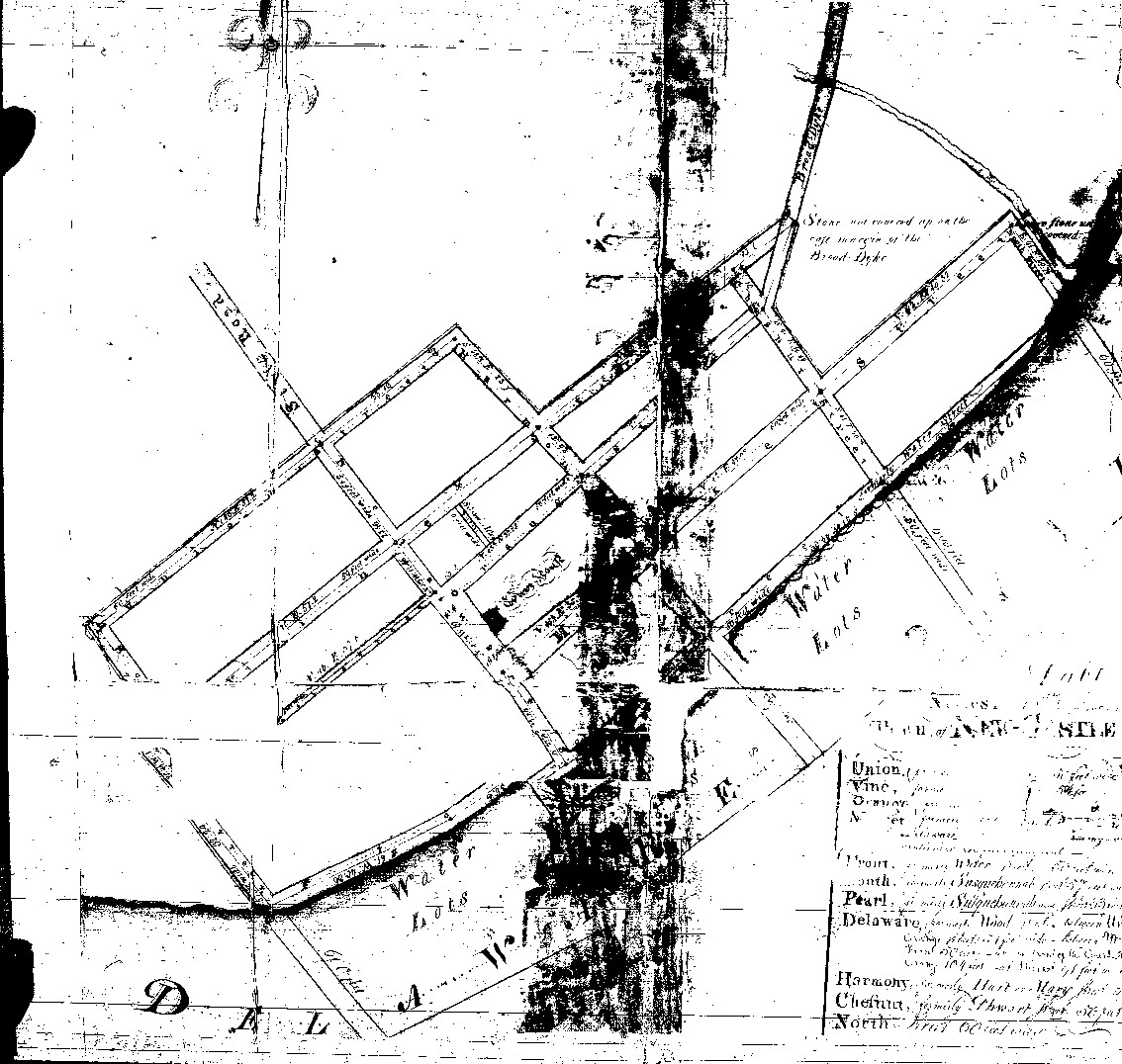
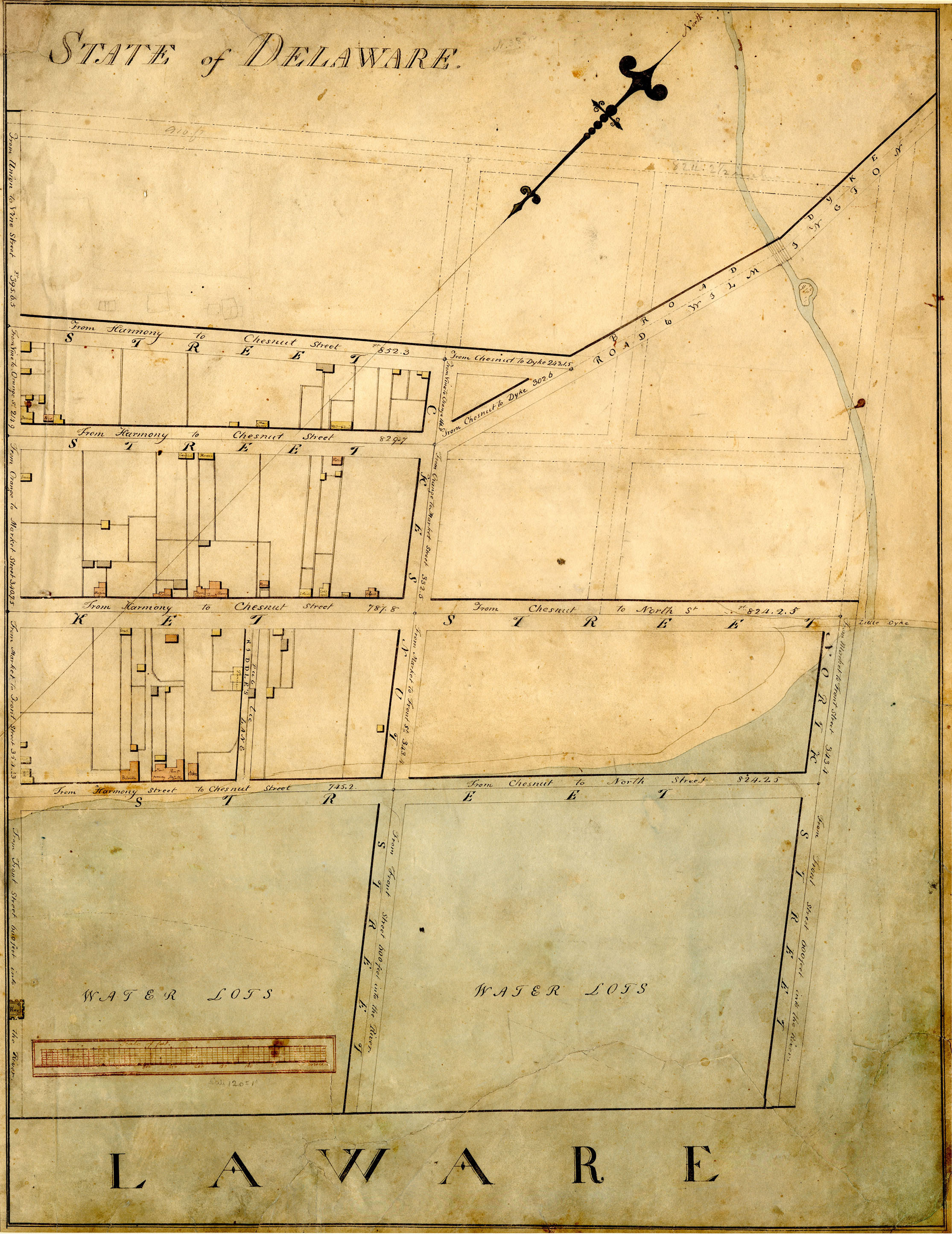
The Dykes (dikes) in New Castle have had many name changes. It can be confusing to understand which dike is referred to in old documents, and when and by whom it was built.
An example is the date give on the historic marker for the building of the Broad Dyke, which may actually be the date for building a dyke 800 feet to the south.

Earlier mentions and names for the Broad Dike include the "Horse Dyke" as the beginning in 1701 of the "12 mile circle" for the northern border of Delaware. (The center of the circle was later defined in 1750 by Lord Hardwicke in English Chancery Court to be the Cupola of the Courthouse.) The Broad Dyke/Horse Dyke was probably chosen as the center for the circle since it was the northernmost part of the town then and in the 1797 survey that defined the limits of the town. I assume it was called the horse dyke since it carried a road, as opposed to the Foot Dyke which carried only a path. As described in the 1906 Sunday Star article by Alexander B. Cooper,
In 1701, we met at New Castle with Cornelius Empson, Richard Hallowell and John Richardson, Justices of ye county of New Castle, and Caleb Pusey, Phillip Roman and Robert Pyle, justices of ye county of Chester, who did unanimously conclude that the Beginning should be at ye end of ye Horse dyke next ye said town of New Castle, and from thence to measure due north, ye said distance of 12 miles, and at ye extent thereof, to run the circular line, first eastward down to the river, and then to return to ye said extent of 12 miles north and run ye said circle westward, said two-thirds part of ye said semicircle. And accordingly ye 26th day of ye said month, we did begin in ye presence of ye said justices at ye said end of ye Horse dyke and measured due north 12 miles to a white oak, marked with 12 notches standing on the west side of Brandywine Creek.
A second dike is about 800 feet away towards the river called the Narrow Dyke in the Blaney Survey report,
and the Little Dyke by Latrobe. The dike is at the end of second street, which was called Dike Street in a 1600's deed.
It was also called the Town Dike (1675 deed), and Foot Dike.
In Cooper's 1906 article on Fort Casimir, he quotes a 1681 deed:
The sd Land being scituate and lying att ye North East end of this towne
of New Castle next to ye foott dyke, beginning att a stake standing near ye said foott dyke and from thence S.W.
along ye Dyke street leading toward Land street [2nd] 598 foott to ye corner of the thwart street [Chesnut], by ye old fort, then N. N. W.
along ye street or way wch goest over ye Great
Dyke...
The Great Dike (Broad Dike) was built in 1675 under orders of the English court for the
purpose of carrying a road.
As described in Scharf
"The English court in 1675 said "Capt. Carr's meadow at the north end of the Towne being represented to
the Court to be a general nuisance to the place and the country as it now is, there being neither bridge
nor fitting way to passe by or through it, and that the Towne is in great straight for want of it,
as they might improve it." Later,
"the aforesaid Magistrates have assembled to-day and considered that the Governor's order regarding the construction of a highway could not be carried out unless an outside dike, with sluices, was first made along the water and they commanded, therefore, herewith that all and every male inhabitant of the district of New Castle shall go to work next Monday and assist in making said dike and continue with his work until the aforesaid outside dike has been completed." The outside dike appears to be Mistress Block's dike or the foot dike, which HAD been built by the Dutch for drainage, but was in poor repair.
Online resources for Dutch and early English documents:
Documents Relating to the History of the Dutch and Swedish Settlements on the Delaware River vol XII, 1877, translated by B. Fernow. available both as text (fast searching but OCR errors) or PDF (very large -47MB and slow to search or read), and from Google Books.
Original Land Titles also known as the Duke of York Record
The dike (to be called the Broad Dyke) therefore was built to carry a road about 1675. What about the 1655 date on the Historic Marker? That would have been an unlikely year for Dutch construction since the Swedes occupied the town until September of that year. I found no reference to it for that year in the letters from the Dutch officials in the New York Historical Documents (Delaware was governed from New Amsterdam, and later was a territory of New York and governed from there until Penn's acquisition). However, the New York Historical Documents, p155 for the following years (Nov. 8, 1656) says
It was further communicated to the community, that it was very necessary to make a bridge over the Kil, running by the Fort, as the passage is impracticable and ought to be made practicable and as in some emergency occurring great difficulties would
arise. They accepted to do this and the 12th inst, being Monday, was set down for it.
I therefore suppose that the 1932 Broad Dyke marker is incorrect on both the date (1655) and which dike was constructed then -- a dike was built in 1656, but it was possibly the
Narrow (Town) Dike near the Fort. Why were the Narrow dike and others built by the Dutch or English? They were not built primarily for flood protection. Lets forget about the little Dutch boy who spent the night with his finger in the dike to save the town in the fictional Hans Brinker.
The Dutch built dikes fitted with sluice gates to allow drainage of marshes and thereby increase pasturage or tillable acreage. For example Beekman in Fort Altena (Ft. Christina, Wilmington) requested land
bordering on the said marsh, which is situated on the westside of Fort Altena and measures by guess about eight morgens. He would inclose it with a dike, if your Honors consent to it, and turn it into arable land."
Battery Park in New Castle was once marsh land. As stated by Eckman
Peter Alrichs had acquired all this Delaware Street land in 1670 on
condition that he improve it and drain the marsh behind the eastern part of
the street. By 1690, he had permitted the marsh to become a nuisance to the
town, and the whole of the marsh and meadow south of Delaware Street,
but not Alrichs' house and garden which adjoined it, was
confiscated. In 1706, it was granted to George Deakyne, who
drained the marsh, built a dyke along the river and a cart-road
from the Strand to Third Street in the approximate location of
what was later the New Castle and Frenchtown Railroad bed.
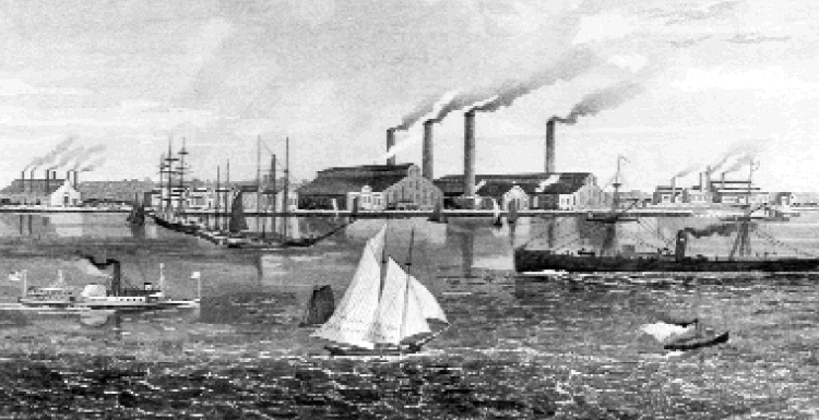
 The history is quite different for a dike/embankment/levee below town adjacent to the Gambacorta Marsh. The marsh is presumably named for
John Gambacorta who came to this country in 1923. But the dike was built much earlier to carry a
single track railroad which led from near the current sailing club boathouse to the
Tasker Iron Works (identified as #6 on the 1906
navigation chart).
The Works was quite large, employing 338 men and 12 boys in 1875.
Remains of the loading dock shown in the chart are still visible at low tide.
The history is quite different for a dike/embankment/levee below town adjacent to the Gambacorta Marsh. The marsh is presumably named for
John Gambacorta who came to this country in 1923. But the dike was built much earlier to carry a
single track railroad which led from near the current sailing club boathouse to the
Tasker Iron Works (identified as #6 on the 1906
navigation chart).
The Works was quite large, employing 338 men and 12 boys in 1875.
Remains of the loading dock shown in the chart are still visible at low tide. According to a newspaper account reprinted in the Delaware Geological Society report on the Hurricane of 1878
Four of the houses on the upper part of Market Street [Bull Hill?]
were carried fully a mile and a half inland by the sudden rise of the
Delaware River. The banks were broken all along the riverfront.
A bank refers both to the shore of a stream and to artificial
dikes that were placed along the shores of a stream to keep out
abnormally high tides. Tasker's Bank suffered the worst,
with the employees at the Iron Works being driven from their avocations. The railroad along the shore was completely
destroyed even though the bank was stone-faced and over 60 feet
wide on top; damages amounted to about $25,000.

What looks like the remains of the railroad is visible at low tide along the waterfront between the boathouse and range light. Phee Price and Ken Boos pointed out to me what looks like a series of ties between the current dike and what looks like a wooden rail. Was this a railroad in the 1870's?

What looks like the remains of the railroad is visible at low tide along the waterfront between the boathouse and range light. Phee Price and Ken Boos pointed out to me what looks like a series of ties between the current dike and what looks like a wooden rail. Was this a railroad in the 1870's?
Flood Hazard
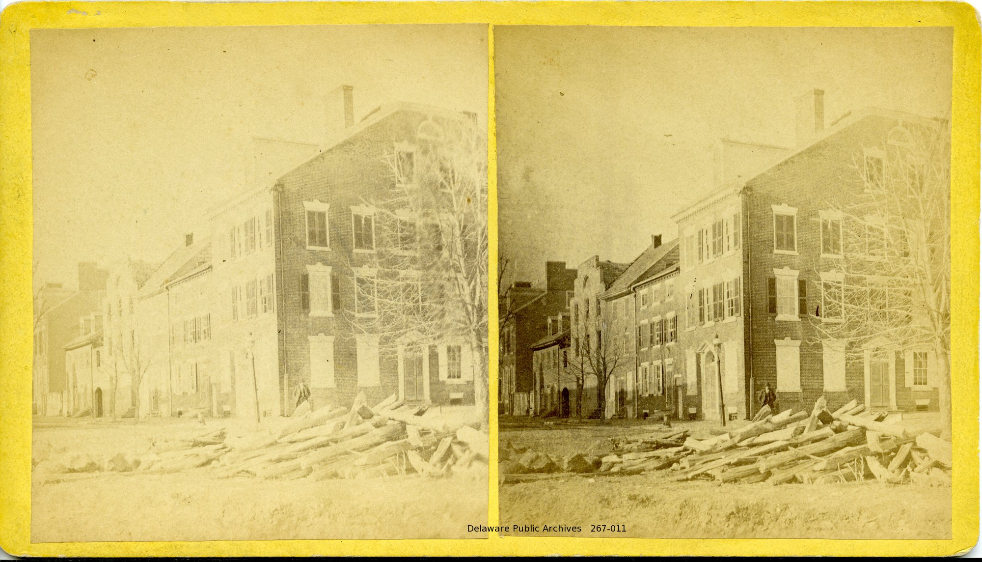
The storm of 1878 did destroy Tasker's Bank, as mentioned above as well as cause flooding and extensive damage all along the Atlantic Coast. It probably caused the flood that left the debris on The Strand seen in this stereograph.
How vulnerable are the low-lying sections of New Castle now? The map to the right, taken from he News Journal's real estate map shows the FEMA 100 year flood plain as a red line, the normal waterline in blue.
 (Click to enlarge.) Areas within the flood plain include the river side of The Strand upriver of the Read House, Chesnut Street, most of E2nd Street north of Chesnut (much of Bull Hill), the north side of E 4th Street, and St. Peter's School.
Work began on plans to improve the existing Narrow Dike (renamed the "Broad Dyke" in engineering reports!) That might prevent flooding of the Broad Dyke Marsh, and water coming from the marsh into the town from the back. But it seems obvious that if there is nothing to block water from rising up Harmony and Chesnut streets and from the nearby parks and lawns, the areas mentioned above will be flooded.
 To the left is a contour map of this area. The data was prepared using LIDAR by the state. Shown are countours up to 12 feet above mean sea level. It's clear that there's nothing higher than 8 feet in the area to block rising water and most of the area is much less.
These areas of the historic part of town have been unprotected for hundreds of years. However, sea levels do appear to be rising.
It would take an expert to assess the accuracy of the LIDAR data, the flood plain rating and the effects of the back marshes on this area. While it might be premature, perhaps affected residents, the city and coastal regulatory agencies should consider what might be needed, feasible and acceptable to protect these areas that are vulnerable to rising sea levels and storm caused wave damage.
To the left is a contour map of this area. The data was prepared using LIDAR by the state. Shown are countours up to 12 feet above mean sea level. It's clear that there's nothing higher than 8 feet in the area to block rising water and most of the area is much less.
These areas of the historic part of town have been unprotected for hundreds of years. However, sea levels do appear to be rising.
It would take an expert to assess the accuracy of the LIDAR data, the flood plain rating and the effects of the back marshes on this area. While it might be premature, perhaps affected residents, the city and coastal regulatory agencies should consider what might be needed, feasible and acceptable to protect these areas that are vulnerable to rising sea levels and storm caused wave damage.
 DNREC has created an
online map showing the effects of rising sea levels by various heights. With a 5 ft. rise the areas inundated include all of Bull Hill (E. end of 2nd, Chestnut), 4th street, the George Read II house on The Strand, and all houses on the water side of the Strand.
DNREC has created an
online map showing the effects of rising sea levels by various heights. With a 5 ft. rise the areas inundated include all of Bull Hill (E. end of 2nd, Chestnut), 4th street, the George Read II house on The Strand, and all houses on the water side of the Strand.
Short term protection of New Castle against storms and long term protection against rising sea level rises clearly requires that dikes or sea walls be considered along all of the town's waterfront.
Jim Meek '12
NC-CHAP
NC-CHAP