Where was The Battery in Battery Park?
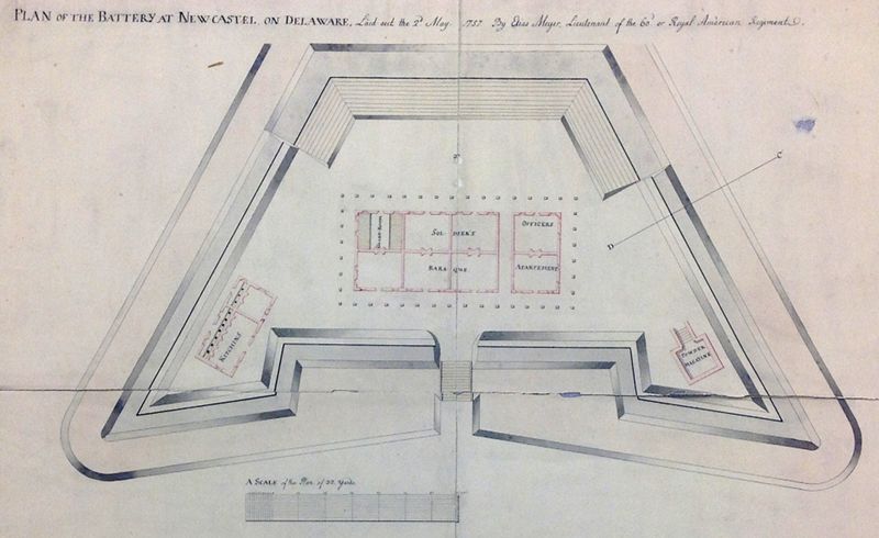
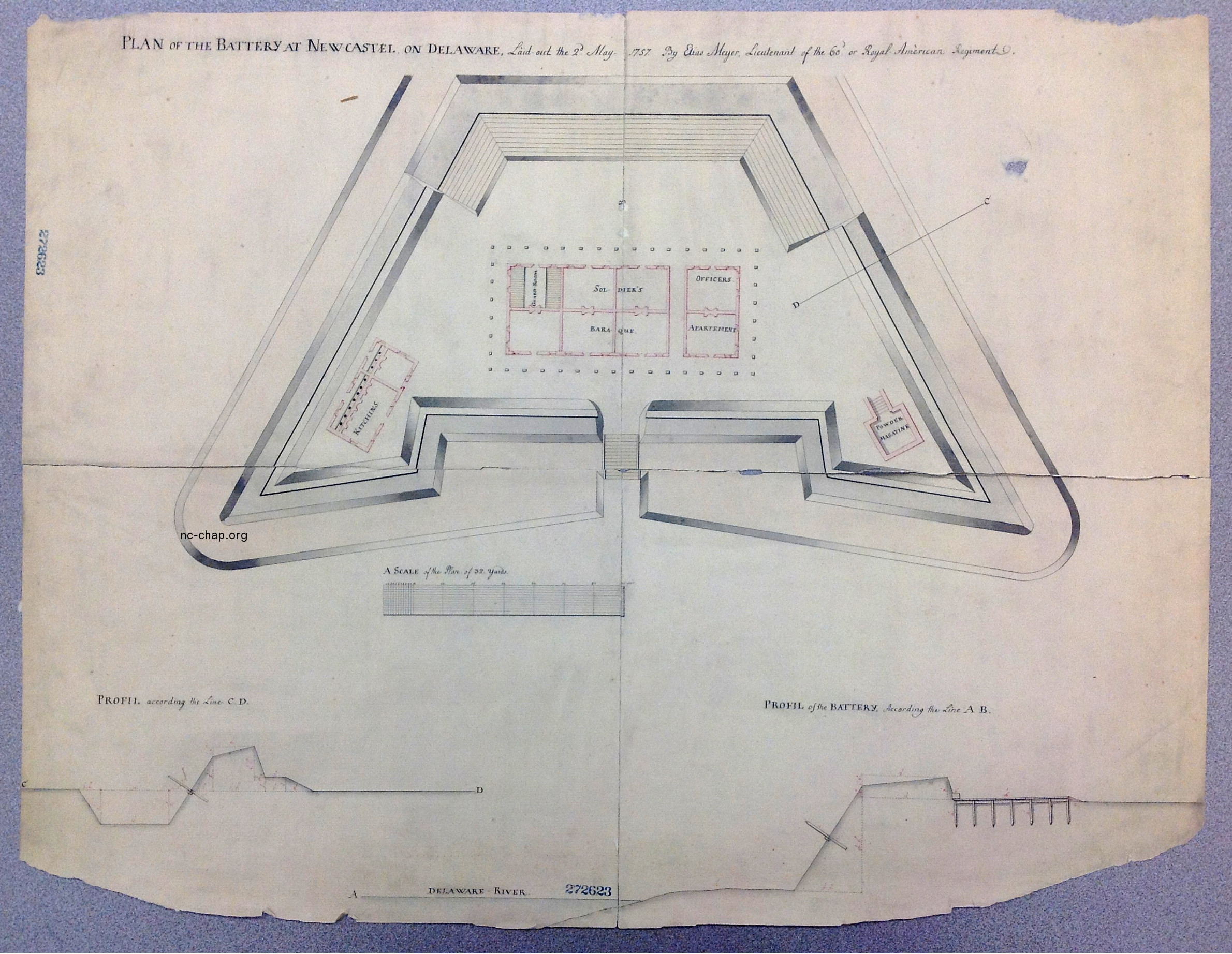
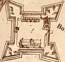
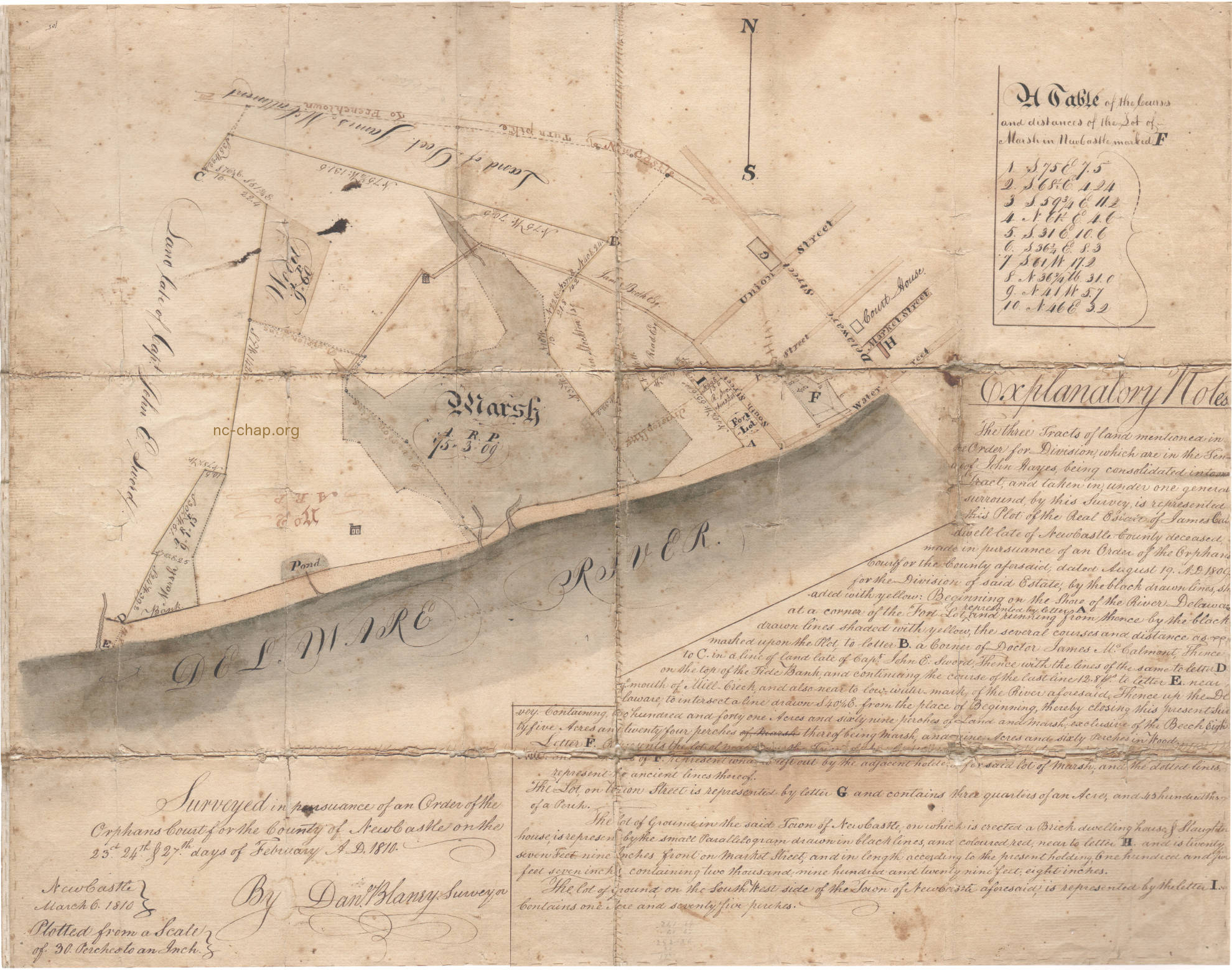
PLAN of the BATTERY at NEWCASTEL on DELAWARE, Laid out the 2d May 1757 By Elias Meyer, Lieutenant of the 60th or Royal American Regiment
Courtesy Pennsylvania State Archives PAHMC MG-11 #517 Click on image to see full size.
Courtesy Pennsylvania State Archives PAHMC MG-11 #517 Click on image to see full size.
New Castle DOES have a Battery Park. But where was the battery? When and why was it built?
It's a complicated story that includes raising funds by a lottery in a time of frequent Indian scalpings after years of pacifist obstruction, a design by a Swiss mercenary, and as a replacement of a simpler fortifications built by a strangely acting Pennsylvania governor to fire on a friendly ship after faking a raid on Philadelphia!
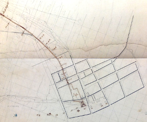
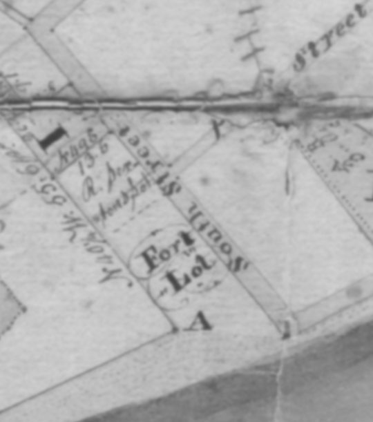 Location of the "Fort Lot" near South and Pearl (W. 3rd) Streets as shown on the 1810 Blaney survey on order of the Orphans Court for property of James Caldwell. The lot immediately north appears to be "R[ichard] Sexton's Lot". Courtesy Jim Hall (DNREC)
- When? Actually there were cannon in battery park in 1697(p17), 1707, 1749?, the one shown above in 1757 and another one in 1809.
- Where? They were built in the "Fort Lot", at the southwest end of town below the intersection of W 3rd. (Pearl) and South streets. Neither is related to the other two forts in town, Fort Casimir (1651-1671) at the the northeast end of town or the fort/blockhouse on the Green (1671-1676).
- Why? The early cannon emplacements were defenses against French and Spanish pirates and privateers.
According to Mervine (1908), they terrorized people on the Delaware from Lewes to Philadelphia.
Attacks came in 1698, 1699, 1704, 1705, 1708, 1709, 1713, 1717, 1722, 1743, 1746, 1747. Attacks stopped when a frigate was stationed at the mouth of the bay.
The first fort was built after the very strangely acting Lieutenant Governor John Evans of Pennsylvania attempted to arouse hysteria by creating a faked attack.
The 1757 battery was built during the French and Indian war. There were 69 reports of scalpings in 1756 in the The Pennsylvania Gazette according to the Accessible Archives index -- more than one per week. The closest was about 75 miles from Philadelphia. The ad in the August 26, 1756 issue for a lottery to raise money for the battery gives a sense of the feeling urgency in the town (and Philadelphia).
- Who paid for it? The lottery was to raise 2000 pieces of eight less 15% commission.
The tickets apparently sold well. Manager Benjamin Chew was one of the most prominent lawyers in Philadelphia, Richard McWilliam, 8 The Strand in New Castle was a judge. Pennsylvania Gazette: September 30, 1756 "The Drawing of the NEWCASTLE LOTTERY will certainly begin on the Twelfth Day of October next. D. Hall has a few of the Tickets for said Lottery to dispose of.SCHEME Of a LOTTERY for raising 2000 Pieces of Eight for erecting a BATTERY at the town of New Castle, and purchasing some GUNS for the same.
THE defenceless state of the town of New Castle, particularly at this juncture, when a war between Great Britain and France seems almost inevitable, renders it exceedingly dangerous for the country around, as well as the Inhabitants thereof: And as the inhabitants from the fewness of their number, are unable to erect any fortification by subscription, that may be of service in time of danger, hoped an undertaking that may, with the divine assistance, not only be the preservation of our lives and fortunes, but, in a great measure, of the last importance even to Philadelphia itself, by warding off the impending evil, or keeping an enemy at play till notice can be given thereof, will meet with encouragement from all lovers of their country and liberties....
So soon as the drawing is finished, the prizes will be published in the Pennsylvania Gazette, and the money paid to the possessors of the 166 large prizes, Twenty per Cent being first deducted, and the 664 small prizes to be paid without any deductions, which makes the deduction on the whole less than Fifteen per Cent.
Proper Notice will be given of the Time of Drawing.
The persons following are appointed managers of this lottery, viz. Benjamin Chew, John Ross, William Patterson, David Witherspoon, Jacob Vanbebber, and David Bush, Esquires; and William Armstrong, John Vandike, Alexander Porter, Richard McWilliam, John Vangezell, William Bedford, George Monro, Zachariah Van Leuvenigh, and Nathaniel Silsbee, Gentlemen; who are to give bond and be on oath for the faithful performance of their trust.
Tickets are to be sold by the said managers, at their respective dwellings.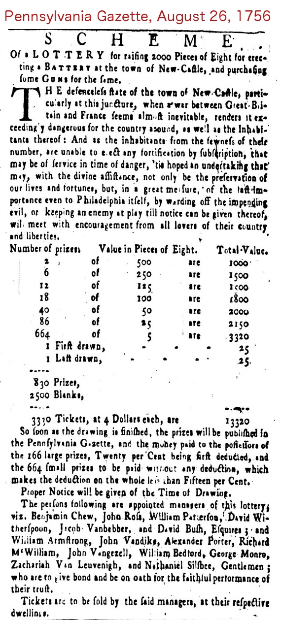
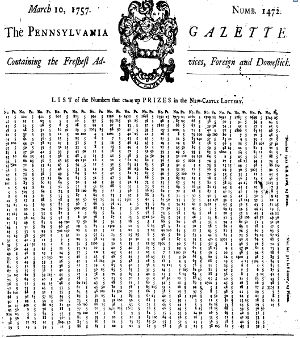
A list of the prize winners was posted as a front page item on March 10, 1757. Then on May 5, 1757 a final notice "THOSE Persons whose Numbers proved fortunate in the New Castle Lottery, and were purchased of David Hall, are desired to call for their Prize Money."
The plans by Meyer shown above were drawn up May 2nd, 1757.
I don't know whether the lottery was the only source of funds for building, or whether the battery was built according to Meyer's plays. The funds were apparently insufficient, since payment on 5th November, 1757 was reported in the Archives of Pennsylvania, vol III: "Gentlemen: Pay the several Labourers & workmen that now are, or hereafter shall be employ'd for erecting a Battery at the Town of Newcastle..." - What kind? The nature of the first fort is not known; only that it contained at least one cannon that could put a shot across one ship's bows. The second fort (battery) is known in great detail from the Meyer drawing, thanks to Wade Catts of John Milner Assoc., who recalled seeing it many years ago at the Pennsylvania Archives in Harrisburg, and photographed it for the DNREC Phase 1 report for the New Castle Dikes refinishing project. I took pictures in Harrisburg of the four separate sheets of the Meyer drawing (map 517) using a hand held iPad and joined the images.
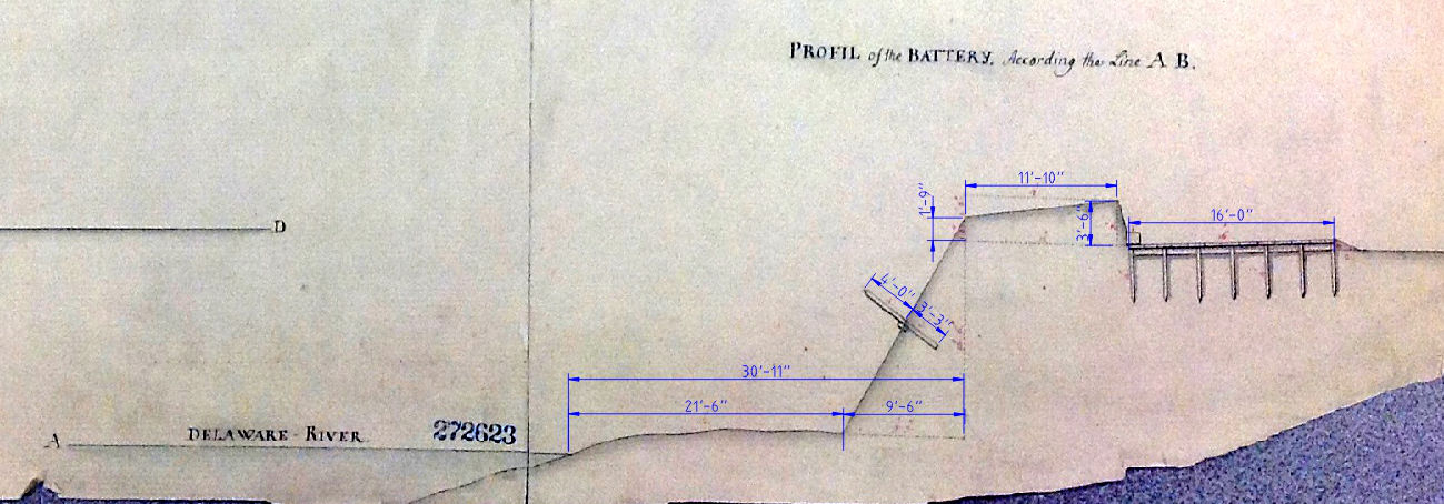
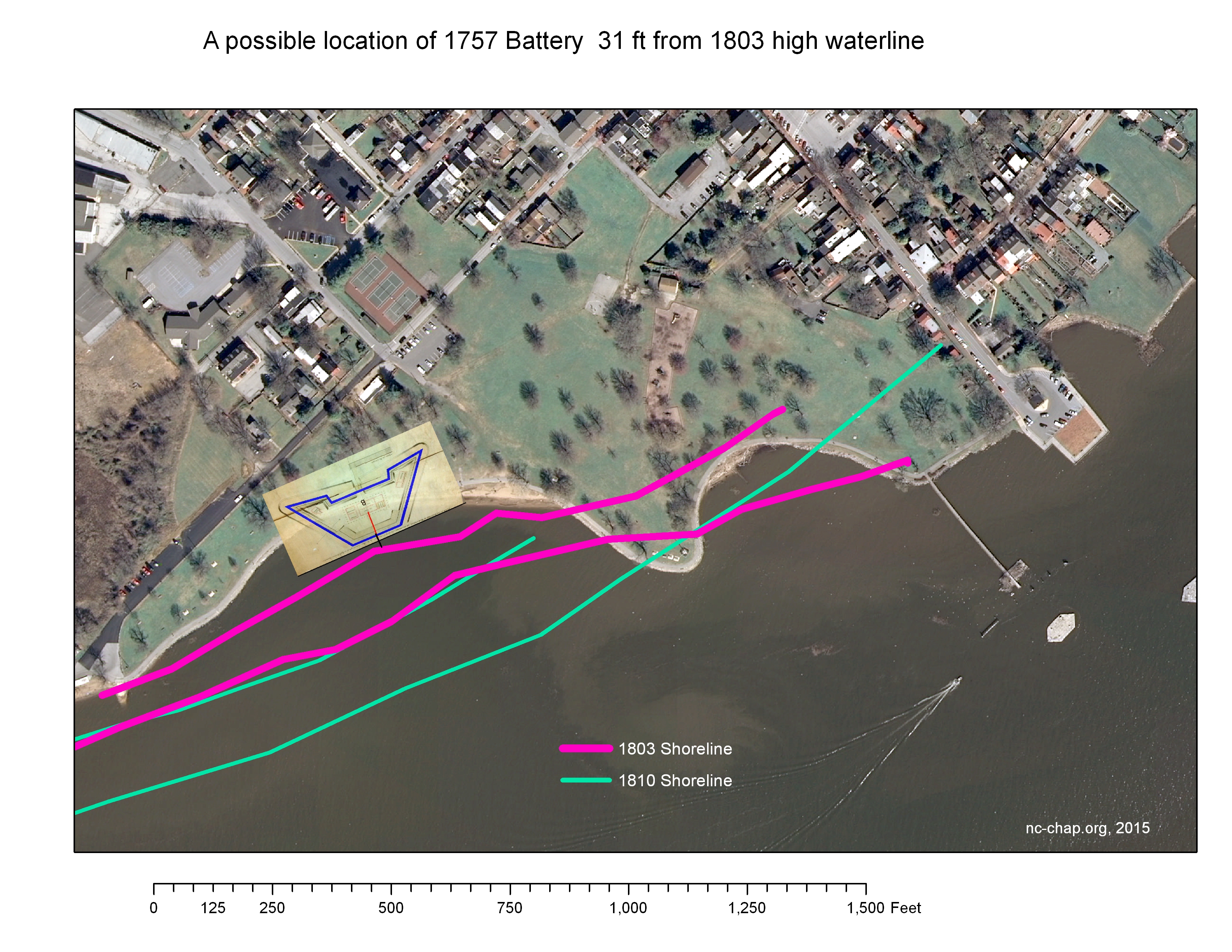
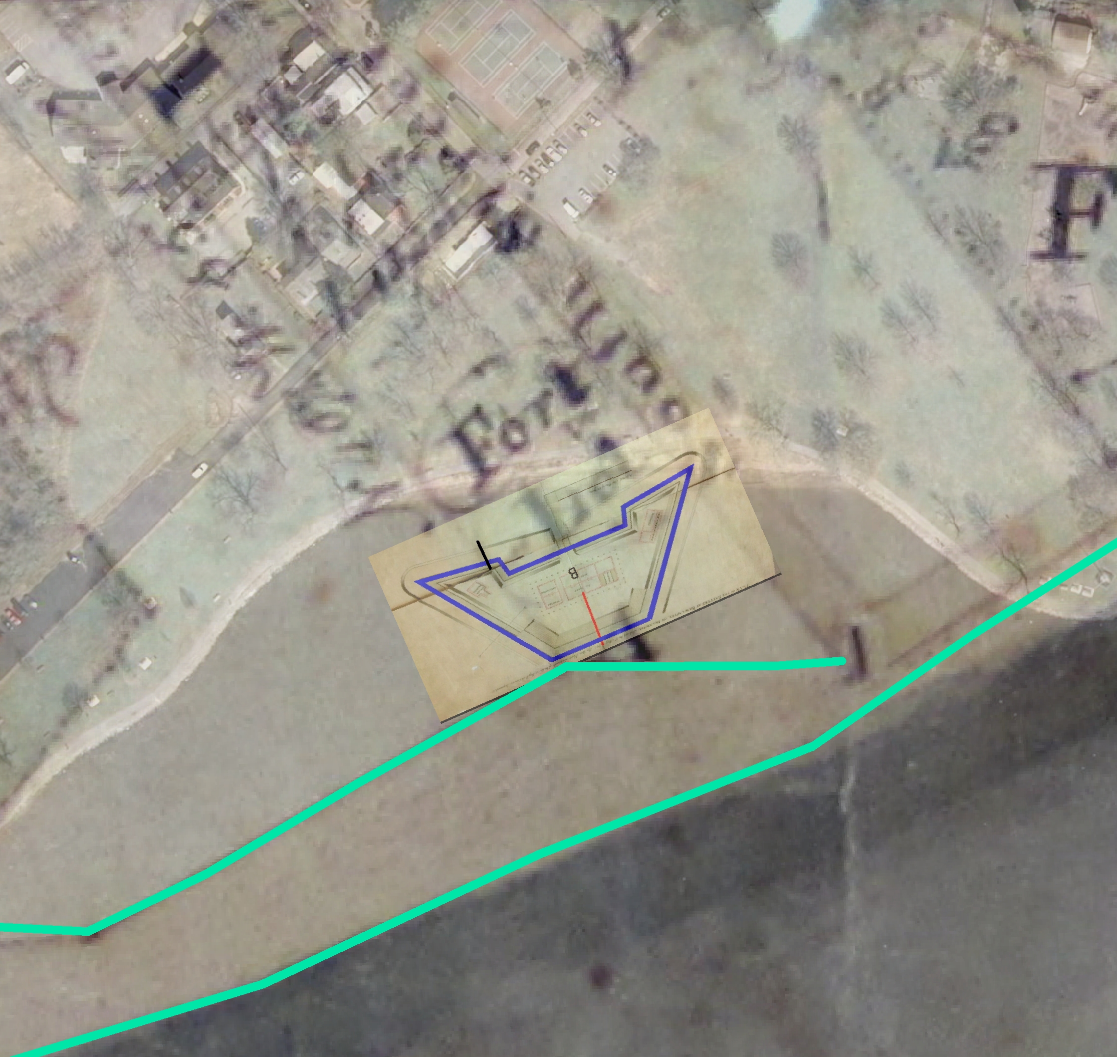
- Where is it now? We know from Meyer's drawing (see measured drawing below) that the leading edge of the battery was 31ft from the Delaware river.
But where was the river's edge in 1757? Was it measured from the high or low tide line?
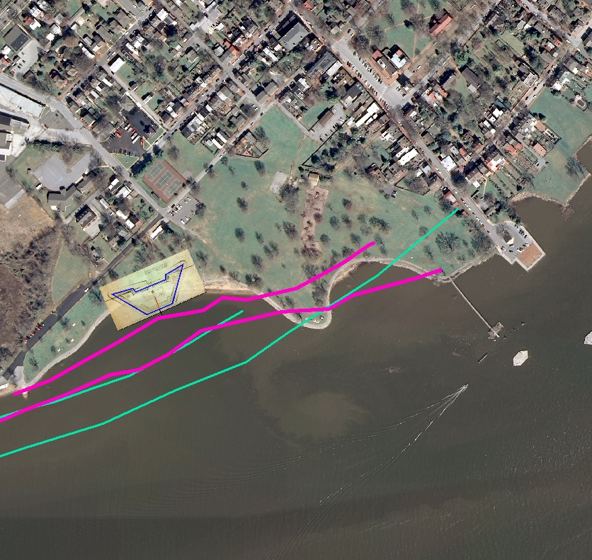 There are no accurate maps of the town from 1757,
but there are from 1803 (Latrobe), and 1810 (Blaney) before railroad construction in Battery Park changed the shoreline. Overlays of the drawing over these maps suggest
that either all or much of the battery has been washed away, but some parts may remain in the knoll in the park. It would be good to look for these with
a Ground-Penetrating Radar (GPR) study of the area especially if any work is planned on the path between the base of the knoll and the beach.
There are no accurate maps of the town from 1757,
but there are from 1803 (Latrobe), and 1810 (Blaney) before railroad construction in Battery Park changed the shoreline. Overlays of the drawing over these maps suggest
that either all or much of the battery has been washed away, but some parts may remain in the knoll in the park. It would be good to look for these with
a Ground-Penetrating Radar (GPR) study of the area especially if any work is planned on the path between the base of the knoll and the beach.
- Who designed it? Lieutenant Elias Meyer of the 60th or Royal Amèrican Regiment.
This regiment was formed because there were insufficient British troops in America to fight the French. Parliament granted funds to hire mercenaries, including foreign Protestants and German and Swiss officers.
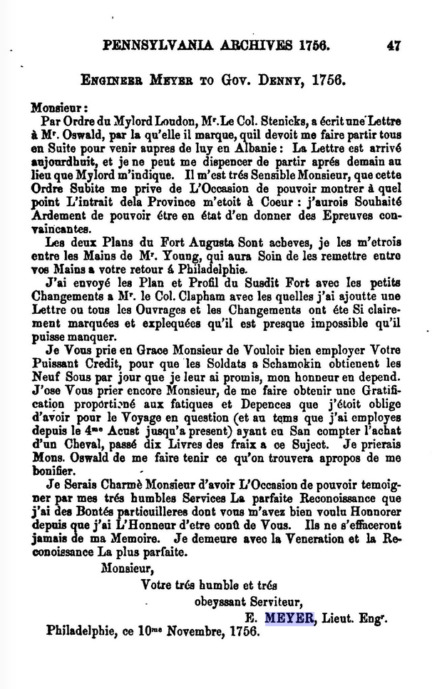
Meyer was commissioned in 1756. Based on his flowery report in French to Gov. Denny, he may have been more fluent in French than English and was possibly Swiss.
He was a trusted engineer: he accompanied Governor Denny and Benjamin Franklin on a trip to visit forts in the frontier in Oct. 1756.
- How do we know so much about this? Three resources coincidentally became available: Wade Catts, rediscovered the Meyer drawing in the Pennsylvania Archives in Harrisburg. But the drawing provides no information as to location of the battery. Then Jim Hall of DNREC sent out an email to members of the local archaeological community that an 1810 orphans court document with a map of the New Castle area was up for auction, and distributed a cell phone image of the document. I noted that there was a "Fort Lot" shown on it, and recalled that there was a mention of it in the 1907 History of New Castle by Alexander B. Cooper and the Scharf 1888 history. Additionally, Catts had recalled seeing maps made in 1803 by Benjamin Latrobe for proposals for a C&D canal between Frenchtown & New Castle which included the New Castle waterfront and the Battery area
- What's the difference between a FORT and a BATTERY?. If a FORT is a military structure or stronghold often occupied by troops and a BATTERY
is a fortification typically with 6 or more cannon, the definitions are somewhat overlapping, and used loosely by various authors.
The story thus has many threads:
Fort Lot and
Blaney (1810)French & Indian
War (1754 1763)Meyer Drawing
1757Canal drawings(1803)
Battery LocationFaked Attack
1706??
The Fort Lot. In 1805, the orphan's court lists property of the late Jasper Yeates as including the "Fort Lot".
When Alexander B. Cooper wrote his History of New Castle 1906-1908 in 45 articles for the Sunday Star, it was clear that there was a "Fort Lot" on the waterfront near the present boathouse. For example in chapter XXXIX, he wrote: "Charles H. Lambson had a lumber yard and wharf on the river a little to the northeast of the present gas house, between it and the old "fort lot."
The Blaney 1810 document provides an exact location of the lot. Daniel Blaney was a surveyor residing in Delaware City. Earlier, he had been hired in 1797 pursuant to an "Act for establishing the boundaries of the Town of New Castle" to prepare a survey of New Castle. This survey is the first extant map of New Castle. The 1810 document reads:
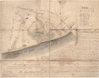 Location of the "Fort Lot" near South and Pearl (W. 3rd) Streets as shown on the 1810 Blaney survey.
The lot immediately north appears to be "R[ichard] Sexton's Lot". A photo of the survey was taken by Jim Hall prior to its auction in 2013. A higher resolution image was kindly provided by Ron Finch. The original has since been donated to the University of Delaware.
Surveyed in pursuance of an Order of the Orphans Court for the County of New Castle on the 23rd. 24th. & 27th. days of February A. D. 1810.
Location of the "Fort Lot" near South and Pearl (W. 3rd) Streets as shown on the 1810 Blaney survey.
The lot immediately north appears to be "R[ichard] Sexton's Lot". A photo of the survey was taken by Jim Hall prior to its auction in 2013. A higher resolution image was kindly provided by Ron Finch. The original has since been donated to the University of Delaware.
Surveyed in pursuance of an Order of the Orphans Court for the County of New Castle on the 23rd. 24th. & 27th. days of February A. D. 1810.
New Castle March 6, 1810 ++++By Danl. Blaney. Surveyor
EXPLANATORY NOTES The three tracts of land mentioned in the Order for Division which are in the tenancy of John Hayes, being consolidated in to one Tract, and taken in under one general surround by this Survey, is represented in this Plot of the Real Estate of James Caldwell late of New Castle County deceased, made in pursuance of an Order of the Orphans Court of the Count aforsaid, dated August 19, A. D. 1809 for the Division of said Estate, by the black drawn lines shaded with yellow: Beginning on the Shore of the River Delaware at a corner of the Fort Lot represented by letter A and running from thence ...
Regarding the first fort on the site, Alexander B. Cooper's article on Fort Casimir, quotes (p24) Scharf's History of Delaware vol I p129 "it is recorded, that in I706 at the secret suggestion of the Governor, the Assembly of the lower counties authorized the erection of a fort at New Castle for her Majesty's service, on account of the war then raging between England, France and Spain. It was however not erected until the winter of 1707, by Captain Rednap, the Queen's Engineer, who was brought from New York by the Governor for the purpose. This fort was built more particularly for the purpose of imposing a duty on all vessels passing the fort, in going up the river from the sea,-consisting of one quarter of a pound of powder per ton, for all vessels owned by persons residing on the Delaware river or bay, and a half of a pound for those owned by all others, excepting only ships of war,-etc.. John French was the first commander of the fort.. This fort it is said and it is generally believed was erected near the river at the foot of what was called' 'Fort Lane," which was, what would now be, the river end of South street extended, on the southwest part of the town."
Cooper states (p25) that this fort was demolished in 1752. This would be just 2 years before the start of the French & Indian war, and just 5 years before the Meyer drawing for a new battery. Strangely, Cooper did not appear to be aware of the lottery to build a fort and the Meyer plans for one.
The French & Indian War (1754-1763) The design of the battery by "Lieutenant Elias Meyer of the 60th or Royal American Regiment" and its building were clearly connected with the French & Indian War which is also known by other not particularly specific names: "Queen Anne's War" (one of three reigning monarchs), Seven Years War, War of the Conquest (it led to the expulsion of French Canadians from Acadia), and perhaps most accurately but not particularly specific "Anglo French rivalry".
The war began in the west at Fort Duquesne (modern Pittsburgh). George Washington, then 22 year old participated in this initial defeat.
What did the battery look like?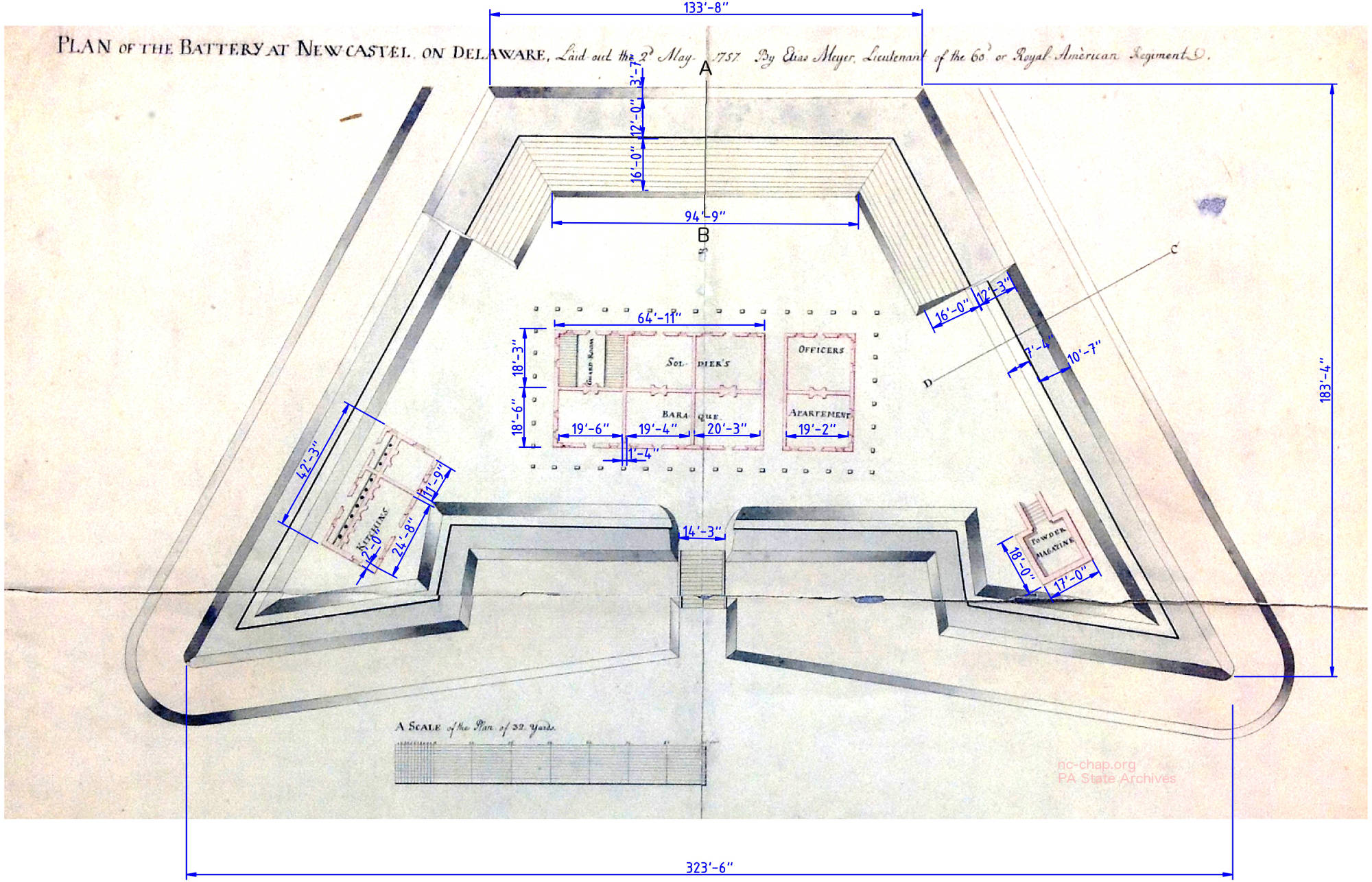 The basic shape is unlike that of usual star forts in use since medieval times with pentagonal bastions that allow unobstructed fire on any attackers. The
battery was surrounded by ditches on two sides and immediately adjacent to the river on the third. The entrance on the fourth side may have been a gate or, as at Fort Duquesne, a drawbridge.
The glacis, or sloped front and side edges had a ~5 ft. poles or fraise extending from them to slow attackers. How many there were of them is not clear, nor is the nature of the walls. They were probably of dirt. For comparison, the
Dutch Fort Amsterdam on Manhattan had four bastions in a c1655 view.
The basic shape is unlike that of usual star forts in use since medieval times with pentagonal bastions that allow unobstructed fire on any attackers. The
battery was surrounded by ditches on two sides and immediately adjacent to the river on the third. The entrance on the fourth side may have been a gate or, as at Fort Duquesne, a drawbridge.
The glacis, or sloped front and side edges had a ~5 ft. poles or fraise extending from them to slow attackers. How many there were of them is not clear, nor is the nature of the walls. They were probably of dirt. For comparison, the
Dutch Fort Amsterdam on Manhattan had four bastions in a c1655 view.
Where was it?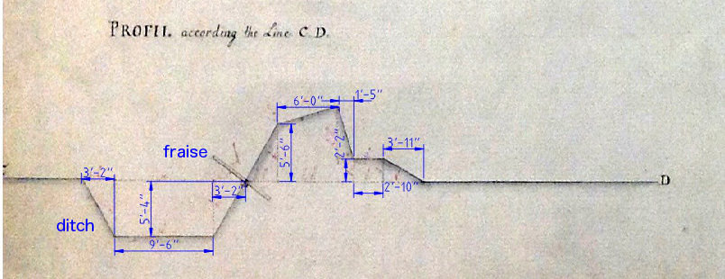
Our only clues are from the profile shown to the right. The front edge of the battery was immediately adjacent to a steep slope down to the water.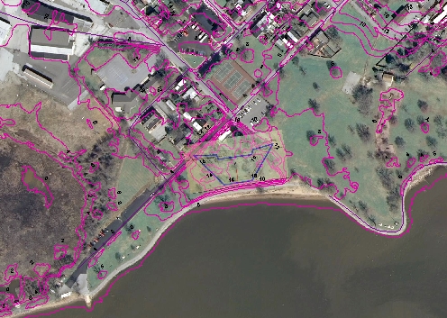 The easiest and most naive guess would be to overlay the battery,
as shown here, next to steep contour lines (pink) that lead to
the water. The battery would snugly fit in what remains of the knoll. Walking on it, and pacing off 100 paces parallel to the water, then 60 paces towards 3rd street
allows visitors to visualize just how big the battery was.
The easiest and most naive guess would be to overlay the battery,
as shown here, next to steep contour lines (pink) that lead to
the water. The battery would snugly fit in what remains of the knoll. Walking on it, and pacing off 100 paces parallel to the water, then 60 paces towards 3rd street
allows visitors to visualize just how big the battery was.
However, it's unlikely that the shoreline has remained unchanged since 1757.
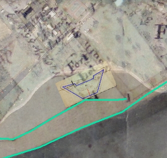
Perhaps the best information on the location of the previous shoreline is from a map prepared by Benjamin Latrobe in 1803 as part of planning and construction for a C&D canal. The sections of the map from Elkton to New Castle are at the Pennsylvania Museum of History (maps 92-97), that of Frenchtown is at the Library of Congress.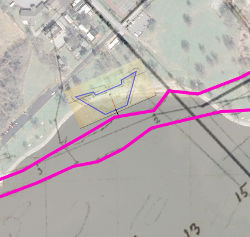
 In the adjacent map, the presumed high and low waterlines are shown in pink, as well as a possible position of the battery 31 feet from the high waterline at an arbitrary point. If that was the position, then parts of the
cookhouse and gunpowder magazine might still be under the hill.
In the adjacent map, the presumed high and low waterlines are shown in pink, as well as a possible position of the battery 31 feet from the high waterline at an arbitrary point. If that was the position, then parts of the
cookhouse and gunpowder magazine might still be under the hill.
The slightly later map, drawn by Daniel Blaney in 1810 (courtesy Ron Finch), shows the shoreline further out. Overlaying the battery 31 feet from that shoreline shows that the site would have been completely washed away if that were the case.
The amazing stories of the Pennsylvania governor who faked a raid on Philadelphia and fired a cannon shot across the bow of a Philadelphia merchant
This story seems to be too amazing to be true.
Read about it in Proud's History of Pennsylvania if you don't mind an old style type face.
Evans (Governor of PA (and DE)) was a non-Quaker replacement for the disgraced William Markham, chosen after Penn returned to England for the last time.Affected by the war:It was hoped that the young (25 year old) Evans would get along with both Quakers and non-Quakers. Instead, Evans was impetuous and prone to brawls in taverns. Evans and a friend lodged in a home "but the habits of both of the young gentlemen were such that respectable housewives soon felt that their absence was more agreeable than their presence". Probably irritated by the pacifist Quaker refusal to build any defenses, he instigated a fake raid on New Castle.
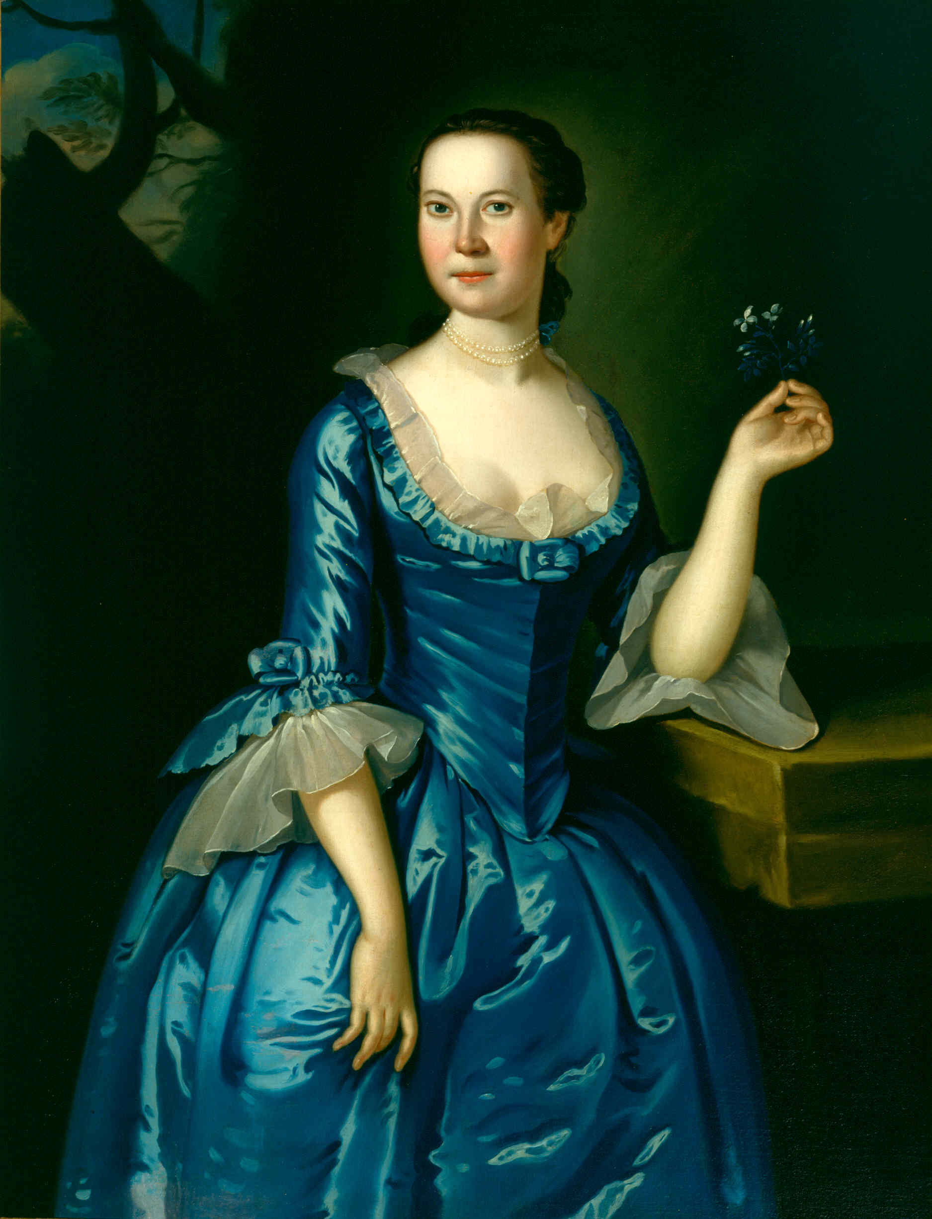
Anna Dorothea Finney of the Amstel House

c1759 By John Hesselius
She was the daughter of John Finney. According to the catalog entry for this portrait in the Biggs Museum, her fiance died in the French and Indian war.
Courtesy of the Biggs Museum of American Art, Dover, Delaware
It was at the time of the fair ...acted by sending up a messenger to the Governor, at Philadelphia, in the greatest haste...[who] with a drawn sword in his hand rode through the streets in seeming great commotion ... The stratagem in part succeeded...some threw their valuable effects down their wells and little houses...
Later he had a law passed to build a fort in New Castle and shakedown Philadelphia merchants to raise money for building defenses. The resulting fiasco might be a comedy of errors!
Gov. Evans proposed to the assembly the building of a fort at New Castle; This law imposed a duty of half a pound of Gun-powder for every ton ... that all vessels ... were obliged to stop, drop anchor and the commander to go on shore, and make report. At length Richard Hill, with Norris and Preston, ... was determined to try to remove this nuisance. He had a vessel; then loaded and just going out to sea; he went in the vessel down the river and dropt anchor a little way before the fort; Norris and Preston went on shore, to inform the officers that the vessel was regularly cleared. Hill, taking command of the sloop stood to the helm and passed the fort... the guns were pointed in such a direction, that a shot went through the mainsail. As soon as the sloop clear of the fort, John French, the commander of it, put off in a boat, in order to bring her to. When he came along side, Hill ordered a rope to be thrown him, upon which they fastened the boat, and French went on board; the rope was then immediately cut, and the boat falling astern, French was conducted a prisoner to the cabin; He was brought on shore to Lord Cornbury, Governor of New Jersey...to give an account of his conduct. After French, in a coarse manner had been sufficiently reprimanded ... he was at length dismissed, but not without marks of derision from some of the attendants. Hill protested to the General Assembly; which protested to the Governor without a dissenting vote. The proceedings at New Castle did not continue.


James L. Meek '15
NC-CHAP
NC-CHAP